


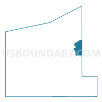
NORTH EAST TWP DIST 02, Erie County, Pennsylvania
About
Outline

Summary
| Unique Area Identifier | 659525 |
| Name | NORTH EAST TWP DIST 02 |
| County | Erie County |
| State | Pennsylvania |
| Area (square miles) | 23.81 |
| Land Area (square miles) | 23.59 |
| Water Area (square miles) | 0.22 |
| % of Land Area | 99.08 |
| % of Water Area | 0.92 |
| Latitude of the Internal Point | 42.20907570 |
| Longtitude of the Internal Point | -79.78959880 |
Maps

Graphs
Select a template below for downloading or customizing gragh for NORTH EAST TWP DIST 02, Erie County, Pennsylvania


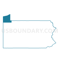
Neighbors
Neighoring Voting District (by Name) Neighboring Voting District on the Map
- Voting District 000000, Chautauqua County, NY
- Voting District 190001, Chautauqua County, NY
- Voting District 240001, Chautauqua County, NY
- Voting District 240002, Chautauqua County, NY
- GREENFIELD TWP Voting District, Erie County, PA
- NORTH EAST TWP DIST 01, Erie County, PA
- NORTH EAST WD 01, Erie County, PA
- NORTH EAST WD 02, Erie County, PA
- Voting Districts not defined, Erie County, PA
Top 10 Neighboring County Subdivision (by Population) Neighboring County Subdivision on the Map
- North East township, Erie County, PA (6,315)
- North East borough, Erie County, PA (4,294)
- Ripley town, Chautauqua County, NY (2,415)
- Greenfield township, Erie County, PA (1,933)
- Mina town, Chautauqua County, NY (1,106)
- County subdivisions not defined, Chautauqua County, NY (0)
- County subdivisions not defined, Erie County, PA (0)
Top 10 Neighboring Place (by Population) Neighboring Place on the Map
Top 10 Neighboring Unified School District (by Population) Neighboring Unified School District on the Map
- North East School District, PA (10,609)
- Wattsburg Area School District, PA (10,412)
- Clymer Central School District, NY (3,208)
- Sherman Central School District, NY (2,840)
- Ripley Central School District, NY (2,056)
- School District Not Defined (Water), PA (0)
- School District Not Defined (Water), NY (0)
Top 10 Neighboring State Legislative District Lower Chamber (by Population) Neighboring State Legislative District Lower Chamber on the Map
- Assembly District 150, NY (121,520)
- State House District 3, PA (60,723)
- State House District 4, PA (58,468)
Top 10 Neighboring State Legislative District Upper Chamber (by Population) Neighboring State Legislative District Upper Chamber on the Map
- State Senate District 57, NY (285,036)
- State Senate District 49, PA (241,903)
- State Senate District 21, PA (235,571)
Top 10 Neighboring 111th Congressional District (by Population) Neighboring 111th Congressional District on the Map
Top 10 Neighboring Census Tract (by Population) Neighboring Census Tract on the Map
- Census Tract 117.02, Erie County, PA (5,370)
- Census Tract 116, Erie County, PA (4,294)
- Census Tract 366, Chautauqua County, NY (3,521)
- Census Tract 117.01, Erie County, PA (2,878)